 Directions
& MapsDirections
& Maps
Directions
& MapsDirections
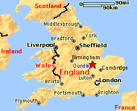
& MapsHere's essentiallly where you need
to get to
(Oundle is marked with the star):
Oundle is in Northamptonshire, about 72 miles northwest of London, 12 miles from Peterborough, and about 8 miles from the A1 road or the A14.
If you are flying into England, Birmingham Airport is about 1 hour away by taxi; ~65 miles driving by car. From London Airports (Gatwick or Heathrow), take the train from the airports into London, then go via Underground to Kings Cross Station and catch a train to Peterborough. By car, London is about 2.5 hours away if traffic is good; 4 if it's not.
By Train: Oundle is 12 miles from Peterborough train station. From London, go from Kings Cross Station to Peterborough Station, which takes about 55 minutes by the fast train on the Great North Eastern Railway (GNER); avoid the very slow West Anglia Great Northern line (WAGN). Taxis are available at the Peterborough station at cost of about £12.
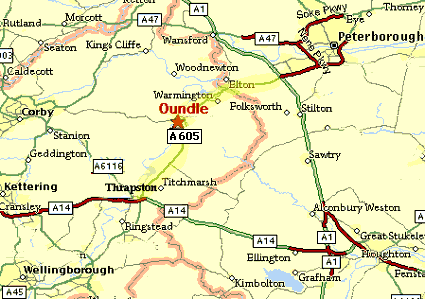
Want a bit more map detail? Click on the map below for a larger look. For a closeup map of the town of Oundle itself, click here.
Driving
Directions:
From London & the South: Take the A1 North to the
A14 West. Then follow directions below marked
**.
From the East: Take the A14 West. Then follow directions below marked with **.
From the North: Take the A1 South past Peterborough to the A605 West (right). Travel the A605 through the Warmington roundabout, and keep following the signs to Oundle. At the next roundabout, follow the signs to Oundle (you will be making a right around the roundabout) onto North Street/A427 (although not well marked as such); follow this until Market Place, when you bear right. The next street is New Street; turn right. The Talbot is immediately on the left. Parking.
From Birmingham Airport (about 65 miles): Watch the signposts carefully as you come out of the airport. Follow signs to the M42 to the North, then take M42 to M6 South, then the A14 East until the sign for "Peterboro A605/Wellingboro/N'Hampton A45" and also the sign for "Thrapston/Oundle/Titchmarsh/Raunds" - take that exit. At bottom of exit, go around the roundabout and go left toward Peterborough A605. Then follow directions below marked with !!.
From the West: Take the M6 South to the A14 East until you see the sign for "Peterboro A605/Wellingboro/N'Hampton A45" and then the sign for "Thrapston/Oundle/Titchmarsh/Raunds" - take that exit. At bottom of exit, go around the roundabout and go left toward Peterborough A605. Then follow directions below marked with !!.
** Travel A14 West to the sign for "Wellingboro/Northampton/Peterborough A45" (IKEA center will be nearby on the right); you'll also see the sign for "Thrapston/Oundle/Raunds/Rushton", followed very shortly by the exit sign "A45/A605"; turn left onto that exit. At end of exit, follow signs for Peterborough A605, turning right around the roundabout. Then follow directions below marked !!.
!! Keep following the A605, and at the next roundabout, go through, following signs to Oundle (still the A605). Go 7 miles. At sign for "Nene Valley/Oundle/Barnwell", follow the sign to Oundle (left). This is Barnwell Road, although it is not marked. Go past The Mill, and over the bridge at the river (there is a light). When you see the church in front of you, turn right onto West Street following the sign to "Town Centre". The next street (War Memorial in the middle) will be New Street; turn left. The Talbot is immediately on the left. Parking directions follow:
Parking: The hotel carpark is past the hotel entrance; travel about 1/4 mile and turn left onto Milton Road (plainly marked), then a quick left again onto Drumingwell Lane and into the carpark. You can also park on the street. A town carpark is behind the Extra foodstore on St. Osyths Lane, signposted from Market Place.
More MapQuest Maps of Oundle and Northampton Area, and in fact, almost anywhere else your travelling heart desires.